
 Story time! The most common question I get from fans of the site, fellow adventurers, and customers while I'm guiding is hands down "how do you find all these obscure but awesome places?" Well, it usually takes a lot of work: many hours of pouring over research, old books, maps, satellite images, and word-of-mouth accounts. And that's just the leg work before packing gear and finding the real logistics to getting there. That said, sometimes I stumble across some of the best destinations for an adventure purely by accident.
To wit: Spring Wood. During my days in Clarion I was searching for the location of the elusive Alum Rock Falls, and narrowed it down geographically to the point that I could find is general area on a map. A friend took that data to the county courthouse to plot it on the tax maps and find the landowner so I could seek permission to visit. The contact info was forwarded to me and when I gave the a guy a ring I asked if it was possible to visit the cliffs on his property which he had pleasantly dubbed Spring Wood. He enthusiastically arranged a meeting with me to discuss my visit.
 After that, I was given basically full freedom to explore his huge tract of private land along the Lower Clarion River and his notes on the coolest features including the cliff so long as I agreed not to camp. When I compared it to my own research something seemed.... off. Aside from the fact he was calling the cliffs Indian Rock instead, everything was just too far apart to be; it had to be different places. I traced everything backwards to realize that my friend had screwed up plotting Alum Rock on the tax maps and his error found a point about a mile further down the river. Yet the landowner gave me directions to a cliff on his property. Confused, I did a quick ultralight trek. Sure enough, there it was: another large cliff overlooking the Clarion River. My friend not only screwed up, but his miscalculation just happened to plot exactly onto another cliff. What a gift!
So eventually I came back, joined by Lavaricky, Buddy, and Ox, with climbing gear in tow to actually spend some time at Spring Wood. There was a lot to see including Indian Rock, some "caves", cascades, and of course my beloved Clarion River.
After the jump, see the madness for yourself...
 Indian Rock was the real point of interest in our travel through Spring Wood, but there was plenty to see along the way. No trail really gets you there; in fact, I found it the first time simply by guessing from the surrounding topography. So to start, our foursome made our way up Ashbaugh Run, where for the most part water just tumbles right over a bunch of boulders and briefly collects into small pools before repeating the process. The water was low but there were some cool cascades that were damn near impossible to photograph. The largest pool, Margie's Golden Pond, was also a stellar rest stop. Unfortunately the combination of low water, difficult camera angles, and my inability to focus a camera do not do the scenery here any justice.


 As we scrambled our way up the stream, the boulders continued to increase in mass and quantity. We diverged from Ashbaugh and made our way around, over, and under these gigantic rocks any way we could, enjoying their immense awesomeness. Especially the notable Sliding Rock Cave, a small but roomy shelter cave which actually created a natural tunnel tall enough to walk through. Not surprisingly, not all of us opted to use the convenient routes...


 |

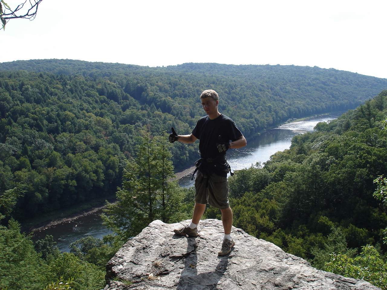 It wasn't an easy walk up the steep mountainside while negotiating these rocks... especially for me since I had all of the climbing gear in my backpack. But we made it not only to Indian Rock, but on top of it. The views of the Clarion River rival and perhaps trump that of both Alum Rock and Seneca Rocks as you get a perfect view down one of the few straight stretched of the valley on the Lower Clarion River. Simply, perfectly stunning.


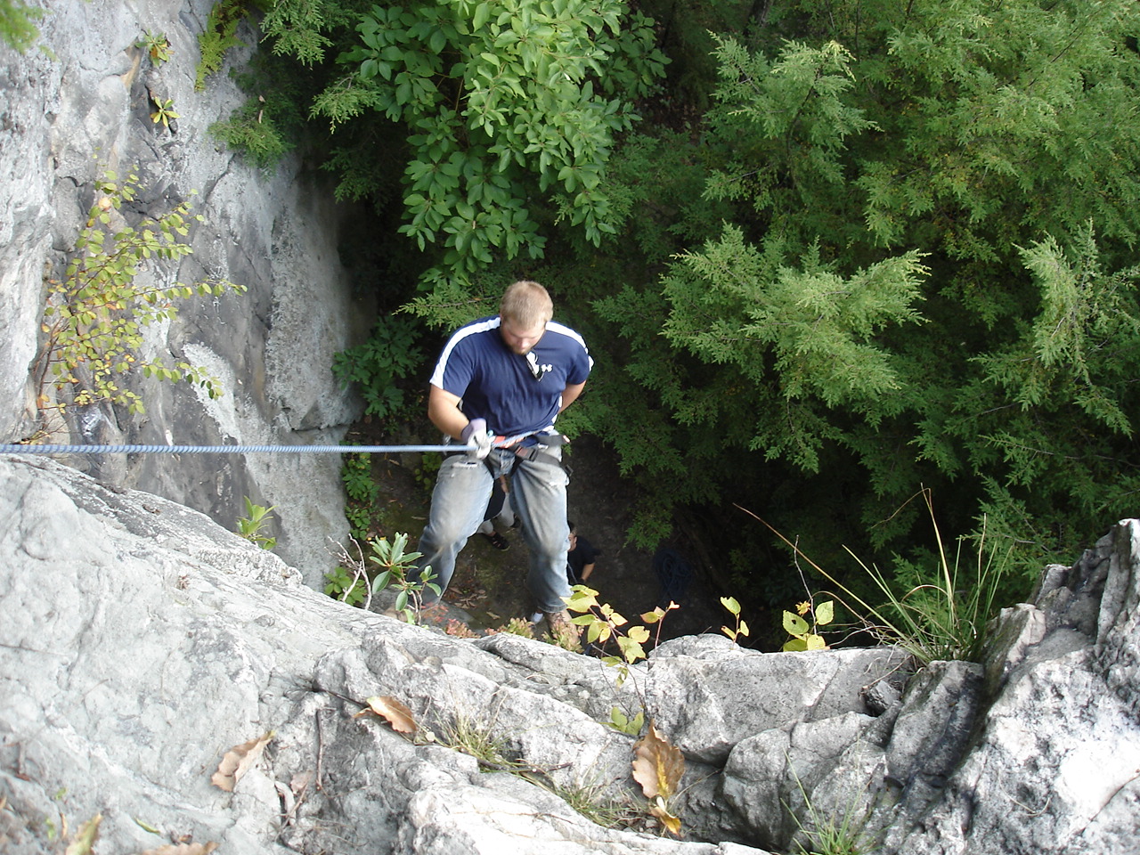
 We enjoyed the view for awhile but I didn't carry 50 pounds of ropes and harnesses for nothing. I tied of a static line up top and dropped it down a clear face of the cliffs for about a 40-50 foot repel. Ox, Lavaricky and myself had some fun with it. Buddy was content to sit at the bottom and stare at my ass while dropped down. Ox and I eventually challenged either to attempt a climb, even though we knew neither of us had enough skill to make it up the mostly featureless rock face. But I still reset the rope for it and we still tried!


 After I broke down the ropes and the like, I had one last thing I wanted to check out: the "Indian Cave" winding into the base of the rock face. It was just a little tectonic gap into the outcrop, but did go surprisingly far. According to old stories about the location, the cave used to open into a much larger room in the back, but was forever destroyed when a man tossed a stick of dynamite into the entrance to keep his kids from playing in it. I have my doubts based on the way the cave looks from the inside, but there was an interesting petroglyph. An early 1800's 'explorer' had carved his name and date right above the cave mouth, claiming to be its discoverer. Again, no proof to that, but an interesting note nonetheless.


 We made the journey back, but on the way I coaxed the group into a detour upstream to the confluence of the Clarion River and Turkey Run. The summer had dropped the river into a trickle through a stone garden, which surprisingly looked really great. Once I was down there, I was immediately able to orient myself based on the old abandoned pipeline running through the river... I've had to dodge that thing many a time while paddling the Lower Clarion.

Finally it was just a matter of riding the Jeep back out of the valley... it was a pretty rough ride down a road that's practically abandoned. But not even a slight challenge for a Jeep! No action shots cuz we were lazy, so this is the best I can offer:

Tally-ho!
-Crash
Wow this is pretty awesome! Did you ever find the falls you were originally looking for? I'd love to explore this area! I go to Slippery Rock University and travel along I-80 each time, and I always try to look for new locations to visit. I'll bookmark this page so I can revisit it to check this comment, but any reply would be great! Thanks!
ReplyDeleteHi I am the same person who posted the other comment on this page. My older sister used to attend Slippery Rock a couple years ago. I know where the waterfall is, but its pretty hard to get to. Are you still looking for it? And can I ask where you're from?
DeleteI am a local resident of the area. I know this post was from 7 years ago, but I find it fascinating that you have a blog featuring these places. You see I have visited both Indian and Alum Rock many, many times. I can easily recognize all of those places you took pictures of. But I see you don't have any pictures of the Alum Rock falls. They are truly magnificant and I consider them to be a local wonder because there are no other falls as large as them any where near the area.
ReplyDelete